A glider’s journey in the Gulf Stream
Written by Joleen Heiderich
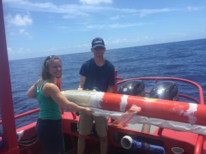
Patrick and Joleen launching the glider from its slide. Photo by Peter Hargreaves, TowBoat U.S. Miami
We are cruising towards the open ocean in a small towboat while the Miami skyline is shrinking in the distance behind us. For Captain Pete, this short trip will be a change from his daily routine. Instead of towing boats, he will help two scientists with the deployment of an instrument in the Florida Strait. His two passengers are Patrick, an engineer from the Woods Hole Oceanographic Institution (WHOI) on Cape Cod, and me, a graduate student in the MIT-WHOI Joint Program in Physical Oceanography.
We are lucky, today the seas are calm and the sun is shining bright. The sea breeze provides a welcome relief from the Floridian tropical heat in July. In the distance, we catch a glimpse of two dolphins playing and jumping in the waves and we can see the outlines of a shipwreck in the clear waters right below us. After an hour, the water color suddenly changes from a sparkling turquoise to a bright azure and we know that we have almost reached our destination. Our mission: deploying a glider in the Gulf Stream.
Have you ever wondered how oceanographers collect data deep in the ocean? Traditionally, we lower instruments from the side of a research vessel and then wait a few hours at each station until we bring them back on board. Fortunately, nowadays we can also use robots to carry our instruments. Using little underwater drones like gliders has the advantage that we do not have to pay for weeks of expensive ship-time, and we can also sample during storms and hurricanes without endangering anyone.
Gliders are autonomous underwater vehicles that can be piloted via satellites. When they are at the ocean surface, they receive a GPS position fix and we can send them new commands and waypoints via the Iridium satellite network. Gliders almost look like small underwater planes that dive through the upper kilometer of the water column in a zigzag fashion. Meanwhile, they are collecting valuable information about their surrounding waters. Among other parameters, they can measure temperature, salinity and pressure to infer the density and depth of different water parcels. Moreover, our gliders carry Acoustic Doppler Current Profilers (ADCPs) to measure current velocities.
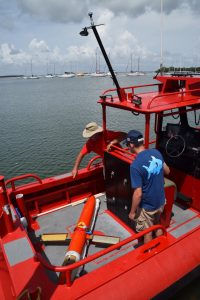
Pete (left) and Patrick (right) getting ready for the glider deployment. Photo by Joleen Heiderich, MIT-WHOI Joint Program
Today, our glider will start its journey in the Gulf Stream. If everything goes according to plan, it will take approximately three to four months to steer it from Miami all the way back to Cape Cod, Massachusetts. In the meantime, it will travel more than 2000 km (1200 miles) while collecting data during each ascending part of its flight. The glider itself only moves very slowly with a horizontal speed of about 0.25 m/s (0.6 mph), but we can use the strong Gulf Stream velocities of more than 1 m/s (2 mph) to push it northward faster.
The Gulf Stream is a strong, warm, and salty current at the western boundary of the Atlantic Ocean. It flows along the US east coast until it separates from the continental margin at Cape Hatteras, North Carolina. Its northern extension crosses the Atlantic towards Europe. The Gulf Stream carries a lot of heat towards the poles, and it thus influences the climate on both the US east coast and in western Europe. Approximately every three month, the WHOI glider group deploys a glider in Miami to survey the Gulf Stream and to get a better grasp of its dynamics. Continuous observations and an improved understanding of the Gulf Stream allow scientists to improve climate and ocean models. In the long run, the glider measurements combined with other observations will allow us to quantify the Gulf Stream’s response to a changing climate.
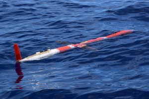
The Spray glider 010 in the Gulf Stream. Photo by Joleen Heiderich, MIT-WHOI Joint Program
Unfortunately, the collection of this crucial data can be difficult since not every deployment goes according to our plan. Possible instrument failures, satellite outages and shark attacks on the gliders make every deployment another adventure. We can only cross our fingers and hope that the gliders will make it back to us, without needing expensive and lengthy repairs. If the gliders get too damaged (e.g. if they lose their tail section during a shark attack), we have to recover them earlier than originally planned without collecting as much data as we would have liked. Rarely, gliders get lost completely. Hopefully none of this will happen to the Spray glider 010 that we are releasing today.
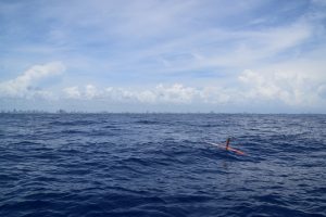
The glider during a satellite transmission test with the Miami skyline in the distance. Photo by Joleen Heiderich, MIT-WHOI Joint Program
Eventually, we make it to our deployment site, slide the glider into the water and try to follow it during its first test dives and satellite transmission tests. This is not very easy despite the calm conditions, since both the glider and our boat are drifting fast. Finally, the Spray glider is ready for its first deep dive and starts descending. We see it vanishing in the deep blue waters before we head back to shore.
Safe travels, 010, and see you back in Woods Hole soon!
If you want to check out where the Spray glider 010 sampled, see http://gliders.whoi.edu/data/archive/17701001.html.