
The ever-growing demand for oil and gas to fuel our cars, heat and air-condition our homes, transport ourselves overseas and power our iPhones has motivated oil companies to search for these fossil fuels almost everywhere on Earth, even under the ocean floor. This includes the Gulf of Mexico, where rich reserves have been pumped from deep below the sea floor for decades. As the demand grows, and technology becomes more sophisticated, drilling rigs are being set up farther and farther from shore and in deeper water than ever. this increases the risk of an oil spill in the ocean that can kill marine life, damage natural ecosystems and harm the fishing industry.
Scientists and the public often focus on the spreading of spilled oil and other pollutants at the sea surface. The oil floating on the surface is easy to see and although it makes a huge mess and causes many problems, we can use ships, satellites with sophisticated cameras and other tools to track where the oil is spreading. The spilled oil is hard to contain and clean up, but at least if we can see where it is, we have a chance.
Some oil and gas that is released in a spill such as the Deepwater Horizon disaster in the Gulf of Mexico in 2010 does not float to the sea surface but spreads out deep in the ocean, even as deep as a half mile down. It is Impossible to “see” where this oil is going and where it might have an impact on deep marine life. The deep currents that would carry the oil from the spill site in the Gulf of Mexico are almost a complete mystery .
My oceanographer colleagues and I have for the past several years been measuring the currents of the deep Gulf of Mexico using an armada of hundreds of buoys that sink down to the depth where oil might spread and drift with the currents there. Since we can’t physically see where they are going, we need to use sound to track them underwater. We have anchored several sound beacons that the buoys listen for to track their progress. Almost everything that these buoys are teaching us has never been discovered before. For example, there is a deep current all around the rim of the Gulf of Mexico, as well as deep swirls of water called eddies. Both would play a role in moving deep spilled oil around the Gulf of Mexico.
To help teach K-12 students about the different kinds of currents we are discovering, we joined Professor Carla Curran from Savannah State University in Georgia to develop a hands-on classroom activity using pipe cleaners to illustrate the tracks of the buoys. Professor Carla is an expert in translating recent scientific research for K-12 students and she has developed more than 20 such hands-on teaching tools about many topics in oceanography. We were pleased to work with her on this project. It is unique in that it is designed to be interesting and accessible to both sighted and blind or visually impaired students. Free copies of the report describing the activity and the science behind it are available for free (while supplies last) at this link:
http://www.tandfonline.com/eprint/3aQh7A7kmSYWa4ZKBC59/full
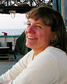 Amy Bower is a physical oceanographer at the Woods Hole Oceanographic Institution. She has been chasing ocean currents in the Atlantic and Indian Oceans for over 25 years, primarily by releasing acoustically tracked floats far below the sea surface. Legally blind since her mid-20s, Amy uses adaptive technology to continue her research.