Three phenomena from geology and geophysics form the foundation of the science mission of our cruise:
- the formation of new ocean crust at the accretionary boundaries between tectonic plates
- the magnetic field of the Earth, which fluctuates in strength and flips direction
- the interaction of this field with newly forming ocean crust to create a record of the field’s strength and orientation through time
These phenomena in combination allow us to make detailed accounts of the magnetic history of the Earth’s surface, and provide reference data to other scientists who will be dealing with rocks of the same age. Since so many parts of the Earth are involved in eventually creating the records we will be observing, let’s start from the very center and work our way outward.
Motion in the outer core leads to magnetic fields which get recorded in ocean crust
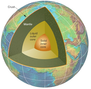
The solid inner core is both beyond the reach of our instruments and largely distinct from the geodynamic system that produces the magnetic anomalies that are our objects if interest. However, the next layer outward, the liquid outer core, provides the source for the Earth’s magnetic field and is thereby the origin of our observations. The Earth’s spin and thermal convection within the outer core generate electric currents, which in turn generate a magnetic field much like a dynamo does; in fact, we call this process the” geodynamo”. Only recently has computing power become sufficient for geophysicists to begin to realistically simulate the behavior of the geodynamo in detail; it is immensely complex and difficult to predict. In fact it is so chaotic that the magnetic poles of the earth have wandered and even switched places many times in the planet’s past, and the field continues to change its direction and strength even now. (The geographic location of magnetic north, where your magnetic compass will point, is always moving. A nice overview of its recent history can be found at Woods Hole’s website.)
Subtle short term variations in the field’s orientation can be observed and recorded during a single lifetime or even, with the right equipment, over the span of hours to minutes. However, different techniques are required to analyze its behavior over the overwhelmingly more vast scale of geologic time. Fortunately, the Earth itself provides us the means. The next layer out from the inner core, the mantle, which consists of rock at extremely high temperature and pressure, experiences its own solid convection motion. In places where these solid convection currents drive molten magma up through rifts in the crust (called mid-ocean ridges, or spreading centers), this material erupts as volcanic lava and gradually cools and solidifies, becoming brand new ocean. Eventually, like a conveyor belt, the aging crust will be dragged further and further from the rift where it originated to be finally consumed by sinking back into the mantle at deep ocean trenches called subduction zones.
As new ocean crust is being created, it cools and solidifies into rock under the influence of the Earths’ magnetic. As the material cools, the magnetic mineral crystals will align their magnetism to the direction of the Earth’s field, eventually freezing that direction in place. Depending on the rate of cooling, the new rock may consist of small crystals (fast cooling, leading to strongly magnetic material) or large ones (slower cooling and weaker magnetic material). Ocean crust is very much analogous to a magnetic tape, slowly created at the spreading center — the area where the magnetic record is written into the rock. When the field is pointing the way it is today (so called “normal polarity” — with magnetic north pointing generally to the geographic north pole), the newly formed rocks’ own magnetic field will be “set” in the same alignment. During periods of “reverse polarity” the planet’s field is oriented in the opposite direction (the magnetic north pole has switched to the south geographic pole), and the rocks will similarly lock in this reversed direction. These fluctuations, written regularly over distance and time in the crust itself, are a record of the Earth’s magnetic history and in our case we are seeking to reveal this history for the Jurassic period.
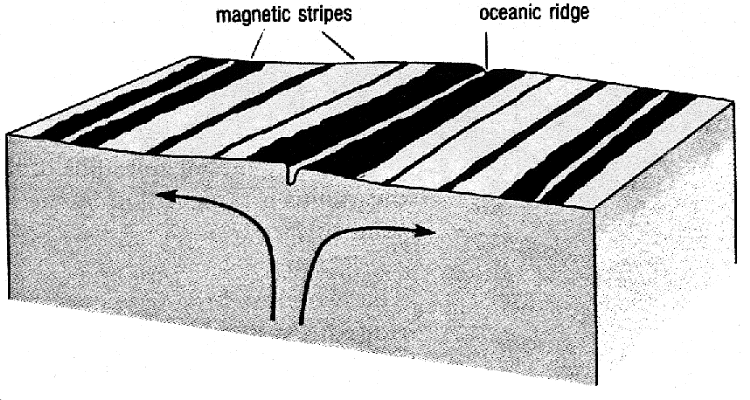
As the ocean crust spreads from the midocean ridge, the polarity of the Earth’s magnetic field is recorded in stripes (deeptow.whoi.edu)
Making our conceptual way outward from the center of the planet, we’ve almost made it to the surface, but there’s still one thing separating us from the magnetic record we’re after: the Pacific Ocean. The oldest ocean crust remaining in the world — the rock from the Jurassic period containing the last unmapped magnetic record — is also the crust nearest the end of its life, closest to the subduction zone where it will eventually be returned to the mantle. A few areas on Earth fit this profile: on either side of the Atlantic ocean, where the Jurassic crust is obscured by kilometers of sedimentary rock constituting the continental shelves of North America and Africa; a portion of the southern African coast near Madagascar, and a triangular region in the western Pacific.
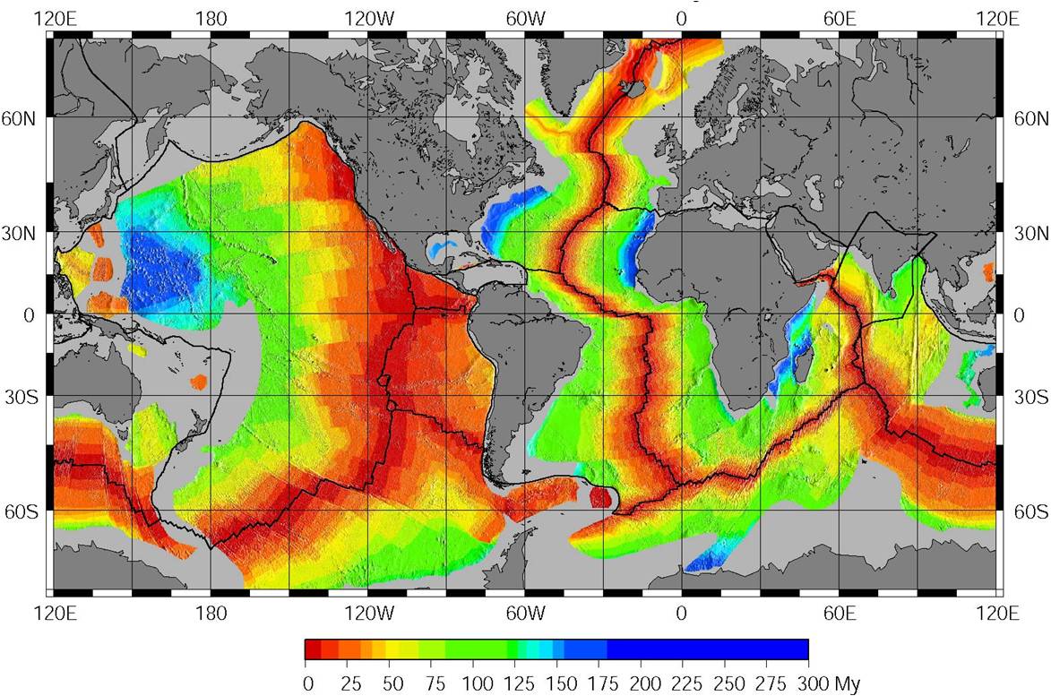
Red denotes newer crust; the blue areas are the oldest oceanic crust (from the work of Müller et al; see more)
Each side of the triangular area in the Pacific represents crust originating from a different spreading center. For this reason, it’s a uniquely useful area for magnetic surveying. By taking readings from each side of the triangle and cross-referencing them, we can hope to construct a comprehensive profile of the history of polarity reversals in the magnetic field during the Jurassic period. This is the overarching goal of a research program that our co-chief scientist Dr. Maurice Tivey has been involved in since 1992. On a series of cruises like this one, Dr. Tivey and colleagues began collecting data on the magnetic anomalies in the Japanese lineations (the west side of the triangle) with a deeptow magnetometer. Since then, each successive cruise has employed more sophisticated sensors and contributed another piece of the whole picture of the magnetic history of the Jurassic Pacific crust. On this cruise and the last (which are mapping the Hawaiian lineations, on the northeast side of the JQZ triangle), the opportunities provided by the Sentry vehicle to make close up observations of these rocks at depths greater than 5000 meters are essential to retrieving high-resolution records of the subtle and faint magnetic fluctuations that occurred during that period.
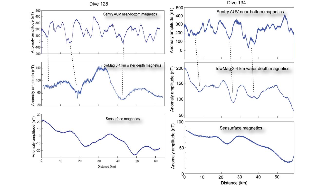
The deeper you go, the more details you see: Sentry (the top of each column) provides by far the most detailed magnetic profile compared to the surface towed and even the deep tow magnetometers
This definitive record at the frontier of magnetic crustal surveying will help resolve questions about what exactly the Earth’s magnetic field was actually doing during the Jurassic period, and will provide an authoritative benchmark against which other magnetic observations from the same time can be calibrated.