How do we know that there was a submarine eruption at Havre volcano?
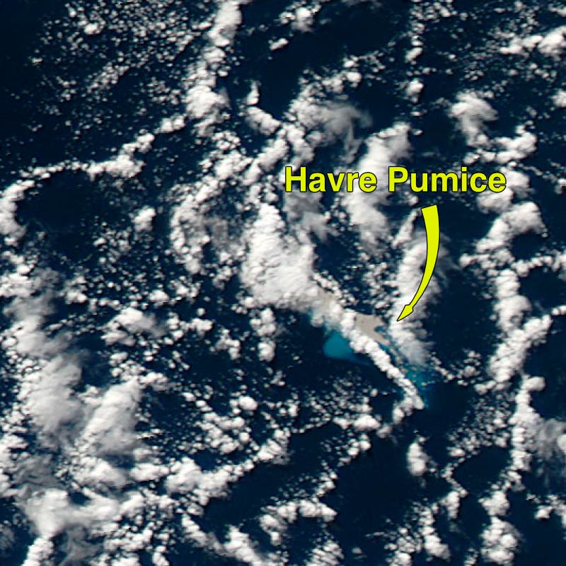 The first clue to this eruption was revealed when a passenger of a commercial airliner spotted large rafts of pumice floating on the surface of the ocean. An examination of NASA Moderate Resolution Imaging Spectroradiometer (MODIS) satellite imagery revealed the likely location of the volcanic source of the pumice raft as Havre volcano and captured images of a steam plume in the atmosphere generated by the eruption. Images acquired between
18 and 21 July show an obvious atmospheric plume on 19 July but only the pumice raft
on 20 and 21 July, suggesting that the eruption lasted less than 2 days and likely just 1 day. Research by the Laboratoire de Geophysique (Tahiti) using data from the Polynesian Seismic network revealed that there had been frequent earthquakes with magnitude 3 to
5 at Havre Volcano between
17 and 21 July 2012, in further support of the eruption timing.
The first clue to this eruption was revealed when a passenger of a commercial airliner spotted large rafts of pumice floating on the surface of the ocean. An examination of NASA Moderate Resolution Imaging Spectroradiometer (MODIS) satellite imagery revealed the likely location of the volcanic source of the pumice raft as Havre volcano and captured images of a steam plume in the atmosphere generated by the eruption. Images acquired between
18 and 21 July show an obvious atmospheric plume on 19 July but only the pumice raft
on 20 and 21 July, suggesting that the eruption lasted less than 2 days and likely just 1 day. Research by the Laboratoire de Geophysique (Tahiti) using data from the Polynesian Seismic network revealed that there had been frequent earthquakes with magnitude 3 to
5 at Havre Volcano between
17 and 21 July 2012, in further support of the eruption timing.
To confirm the source of the eruption as Havre volcano and determine the exact locations of vents on the edifice, the National Institute of Water and Atmospheric Research (NIWA), in New Zealand, conducted a post-eruption research voyage to the Kermadec Arc later in October 2012, which included multibeam mapping and dredge sampling of Havre volcano. The new bathymetry was compared to the previous bathymetry survey of the volcano acquired in 2002, permitting detection of, and precise constraints on, new seafloor volcanic feature.
What are the new features on the seafloor?
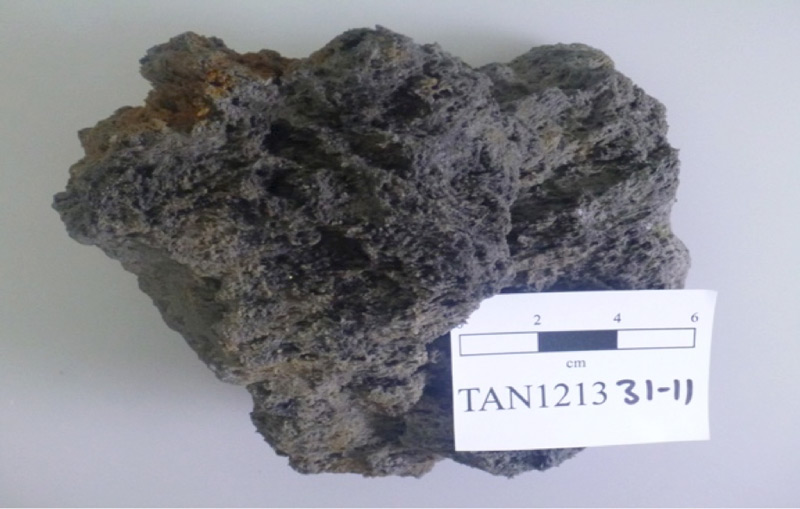
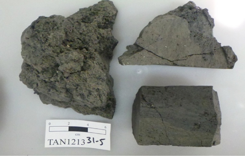
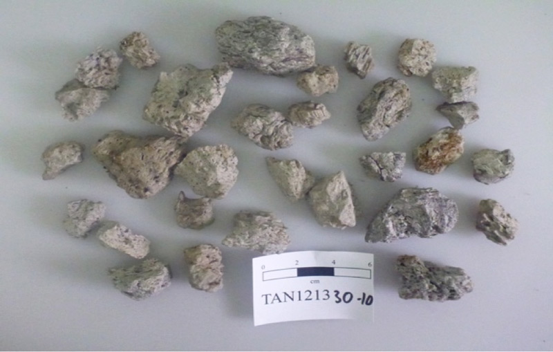
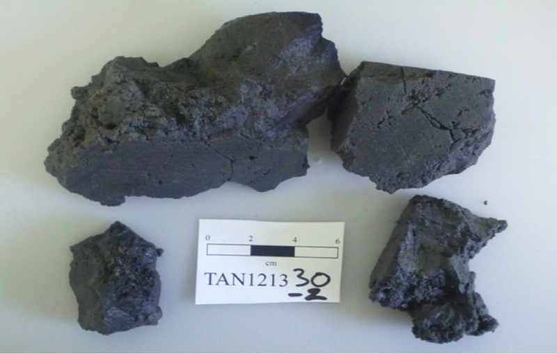
Through this comparison, several new features were found, including a previously uncharted bulge on Havre’s western caldera wall and several volcanic cones (Figure 2). Furthermore, the caldera floor was, in places, more than 50 meters shallower. Seafloor sampling at 10 sites yielded a large quantity of pumice, ranging from dark, dense material to light-colored, lower-density dacite and rhyolite pumice.
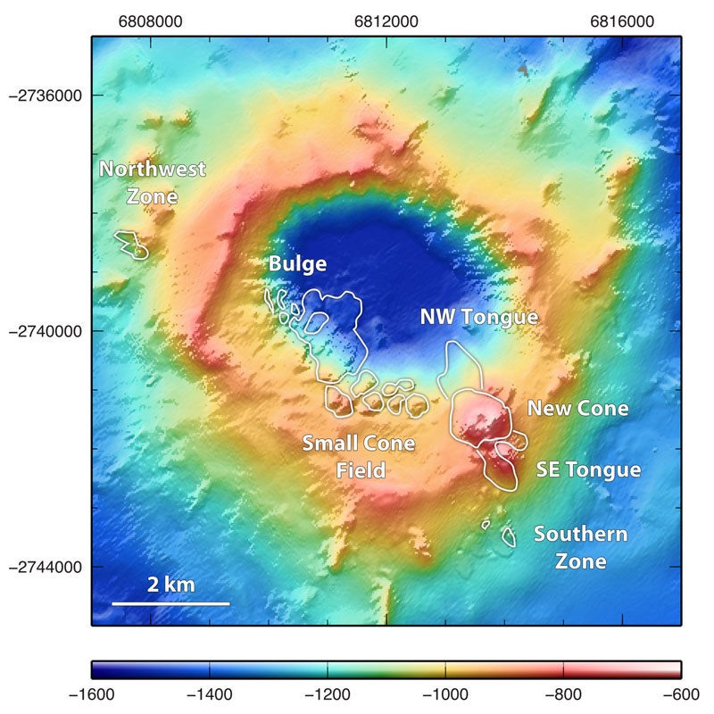
The new features include:
- A new volcanic cone formed at a water depth between 640 and 900 meters below sea level (250 meters high), is 1.2 kilometers across, and has a summit crater 120 meters in diameter. Mapping revealed that four tongues of ejecta, each up to 50 meters thick, extend from the cone’s summit to about 1.5 kilometers to the northwest, north, southeast, and eastsoutheast. These tongues are hypothesized to be associated with primary or resedimented gravity currents of tephra.
- A small cone field also formed that consists of about eight new cones, each up to 300 meters in diameter. These features have bases at 940 meters below sea level and deeper and range from 60 to 115 meters in height.
- A bulged area between approximately 1080 and 1400 meters below sea level (with a maximum gain in height of 150 meters). The origin of this feature is unknown, but possibilities include the accumulation of proximal suspension-settled or resedimented volcanic ejecta, extrusion of a dome, or intrusion of a cryptodome.
Previous mapping of the edifice of Havre volcano and the bathymetry surrounding it indicates that the eruptive vents initially must have been located at depths more than 720 meters below sea level (the shallowest point on the volcano), which would make it the deepest submarine silicic eruption ever documented. These 2012 volcanic features are the focus of AUV Sentry and ROV Jason exploration in March 2015.
How big was the eruption of Havre?
The magnitude of the Havre eruption in 2012 is based on preliminary volume estimations of the products transported into the raft and those deposited on the seafloor calculated by comparing pre-eruption and post-eruption bathymetry maps. These calculations suggest a bulk erupted deposit volume of about 1.5 cubic kilometers, which is equivalent to 1.5 times the volume of the Mount St. Helens eruption on 18 May 1980, or about 10 times the volume of the 2010 Eyjafjallajökull eruption in Iceland.
Although these are preliminary estimates, they place the 2012 Havre eruption as magnitude 5 on the volcanic explosivity index, making it probably the largest (in addition to being the deepest) historical submarine explosive eruption ever documented. Equivalent-sized subaerial eruptions are dramatic once-or twice-a-century events.
Why is this eruption important?
The eruption of magma in deep submarine settings is poorly understood—many of the world’s submarine volcanic arcs remain largely unexplored, submarine silicic eruptions are rare events, and the precise role of hydrostatic pressure (because of the weight of the overlying water column) in modulating eruptive dynamics is unknown. In fact, had this explosive eruption not occurred, it would likely not have been predicted because of the prevailing idea that hydrostatic pressure at the eruption depth (which exceeds 9 megapascals) can significantly suppress explosivity.
The depth to which explosive silicic volcanic eruptions can occur is controversial, but few observational data exist to inform that debate, making studies at Havre invaluable for exploring thresholds. Further, the eruption yields another obvious question: What processes promoted the development of a sub-aerial eruption plume from seafloor depths of up to 1400 meters below sea level?
This eruption provides a rare opportunity to further the understanding of deep submarine volcanic eruption processes and is enhanced by unprecedented constraints such as hydrostatic pressure at vents, timing, ejecta volume, and its dispersal.