How We Work
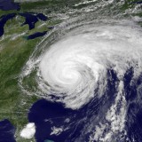
Every good investigation starts with important questions. When and how many hurricanes have hit the US East Coast in the past 2,000 years, and what does that mean for the future? Is sea level rising? How fast? Can we protect a community and ecosystem from hurricane winds and floods?
In an effort to answer these questions we need to find the evidence, and the evidence we need is buried in the mud in back barrier coastal ponds.
Field Methods and Equipment
Data collection starts with identifying an appropriate coring location. Our objective is to find locations, either a pond behind a beach barrier or a salt marsh that are relatively undisturbed. We are looking for uninterrupted layers of mud that represent thousands of years of continuous time.
Lab Methods and Equipment
While collecting cores is an exciting part of our work, we spend the vast majority of our time in the lab working up the data. Lab work is detail oriented and includes opening up the cores, pulling leaves and stems for carbon dating, sieving the sediment to identify layers of sand (that are proxies for hurricane events). Lots of people are busy in the lab all year round processing the detailed data that will be used for analysis.
Data Synthesis
Making sense of the extensive evidence preserved in the sediment samples allows us to synthesize our thoughts and understand the chronology of the geologic region. This includes analyzing sea level changes over time and/or developing a hurricane frequency story.


